I was shooting for a new Real Estate Client (as part of my FotoSul venture) in Luz de Tavira in the Eastern side of the Algarve.
To complement their portfolio I took to the sky to photograph their nearest beach of Praia do Barril, a long golden sandy beach with sand dunes that makes up part of the Ria Formosa Natural Park.
{Click image(s) to view on Flickr - opens in new tab}
You may remember a film I created back in the summer called “Consequência – Depois dos incêndios” showing the destruction caused by the Monchique Wildfires.
Last week I was contacted by a film company who is making a new documentary titled “Tudo é Paisagem” (“Everything is Landscape”) about the History of Landscape Architecture in Portugal. This has been commissioned by the Associação Portuguesa dos Arquitectos Paisagistas (Portuguese Association of Landscape Architects).
Yesterday we agreed terms and I have supplied various shots for inclusion in their documentary. As you can imagine, I’m pretty excited about this collaboration.
I will share more information at a later date, but for now if you haven’t watched my film from back in August you can view it below;
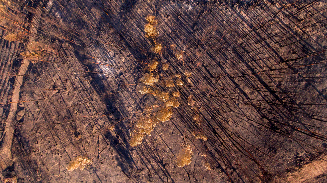
Almost 2 weeks have passed since the fires of Monchique were finally extinguished. Once the fires were out, I made a trip around the locally burnt areas and was shocked at just how large an area was affected and the amount of devastation left behind, I was (and still am) genuinely saddened by the scenes. I was determined to try and capture the scale of what happened to the almost 28,000 hectares burnt within just 7 days.
It has taken a fair amount of filming and editing to bring you “Consequência – Depois dos Incêndios” which translates to “Consequence – After the Fires”. Up until yesterday, I was still filming and still you can see areas of ash with smoke rising and occasionally there seems to be small flare-ups in the areas, particularly around Monchique. As you will see in the film, some of the ground has white ash spots or holes where trees once stood and have completely vanished. Other areas have an eerie beauty, such as the Eucalyptus trees with their scorched leaves, at first they appear to be stunning Autumn colours, of course, they are not.
Feel free to share this YouTube video, however, one thing I strongly ask is it is not used in any political argument about how bad or good the emergency services dealt with the situation. I did not create this film with any bias towards either side of the argument. For the record though, I am amazed at how well properties have been saved. The video is available in both HD and 4K if you have the Internet bandwidth and/or equipment to play it in those resolutions.
The devastation fires have long gone, although there are still patches smoking and a couple of flare-ups still occurring, and I’ve finally captured Drone footage from many areas inside the burnt area.
The scale and size of destruction is so large that I want to be able to show others just how large this fire was. It will now take a few days to edit all the clips into a short video titled “Consequência – depois dos incêndios”, which translates to “Consequence – after the fires”.
Here is a quick photo I snapped whilst the drone was hovering above an almost totally destroyed Eucalyptus area near Monchique.
After more torrential rain overnight thanks to Storm Felix, the River than runs through our land has again flooded. So today I took the drone up to get a birds eye view.
Just 10 days ago the river was still dry from last summer. In just these 10 days it has flooded twice due to the deluge of rain. It’s the River Odelouca which feeds the Odelouca Barragem, the main drinking water supply for the Algarve, so the water is very welcome apart from the flooding which will cause some issues for the wildlife living around the banks.
Keep a look out after 30 seconds, you can just make out the Fox Hole on the side of the track on the left where the water level has reached, hopefully it won’t flood the den.
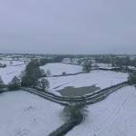
Snow Cover
At home, near Marchington in East Staffordshire, we had around 2 inches of snow overnight, so I thought I’d send the DJI Phantom 3 Pro up to capture some of the patchwork fields covered in snow.
Even though the area is quite flat with just the famous “Cliff” in some of the shots, the snow really makes for some stunning scenery. It’s amazing how everything looks almost black and white when snow is on the ground and the sky is overcast. Just a little glimpse of green grass poking through the snow in the fields.
Here’s a short video of some of the footage.
{Remember to watch in HD if possible}
This website uses cookies to improve your experience. it's assumed you are happy with this, alternatively you may opt out.AcceptRead More
Privacy & Cookies Policy
Privacy Overview
This website uses cookies to improve your experience while you navigate through the website. Out of these, the cookies that are categorized as necessary are stored on your browser as they are essential for the working of basic functionalities of the website. We also use third-party cookies that help us analyze and understand how you use this website. These cookies will be stored in your browser only with your consent. You also have the option to opt-out of these cookies. But opting out of some of these cookies may affect your browsing experience.
Necessary cookies are absolutely essential for the website to function properly. This category only includes cookies that ensures basic functionalities and security features of the website. These cookies do not store any personal information.
Any cookies that may not be particularly necessary for the website to function and is used specifically to collect user personal data via analytics, ads, other embedded contents are termed as non-necessary cookies. It is mandatory to procure user consent prior to running these cookies on your website.